Marine erosional processes
- Hydraulic action – Air is trapped in the joints and cracks of a cliff by a wave. This exerts pressure on the rock wall. As the wave retreats, the pressure is released with a sudden jolt, causing parts of rock to break off.
- Corrosion – Parts of a cliff are eroded by the acid of the sea water which dissolves elements such as limestone or chalk.
- Attrition – Two or more rocks collide and bump into each other, breaking off fragments and making the rocks smaller
- Abrasion – Rocks are thrown against a cliff, breaking off fragments and wearing them away.
Marine transport processes
- Traction– large boulders are rolled along the sea bed
- Saltation– smaller rocks bounce along the sea bed
- Suspension-particles suspended in the water float through the water
- Solution– Transport of dissolved materials in the water
Marine deposition
Sediments may deposit in sheltered areas where land has a lower gradient. This is aided by constructive waves.
Constructive and Destructive waves
Constructive waves:

- strong swash (movement of water up the beach) and weak backwash (movement of water down the beach)
- eliptical orbit
- low
- low frequency
- depositional
Destructive waves:

- weak swash, strong backwash
- circular orbit
- high
- high frequency (more than 12 per minute)
- erosional
Wave refraction and longshore drift
Waves may approach the coastline at an angle due to the direction of the wind.
Waves are refracted at 90° from the coast under the force of gravity.
If these steps are repeated, particles are transported along the coastline (in a zig-zag fashion). This is known as longshore drift.

Formation of bay and headland
Bays and headlands form in areas of coastline that have alternate bands of hard and soft rock. Hard rock is more resistant to erosional processes, whereas soft rock is more easily worn away. Soft rock forms a bay when it is eroded, whereas the hard rock remains to form a headland.
Formation of a wave-cut platform
- A wave-cut notch develops at the base of a cliff due to erosional processes.
- The rock above the notch is weakened and develps cracks and joints.
- The notch expands and can not support the rock above.
- The rocks break off and the cliff retreats.
- The eroded material is transported away (and the previous steps are repeated)
- A wave-cut platform is developed
Formation of caves, arches and stacks
Caves, arches and stacks are usually found on headlands, as these are eroded by the waves from three sides. They form as cracks/weaknesses in the headland are widened due to hydraulic action, abrasion and solution, leading to the creation of a cave. As the cave widens due to further erosion, eventually it cuts through the whole headland to form an arch. The top of an arch may collapse when it is unsupported, leaving behind a large vertical rock known as stack. When erosion weakens a stack, it eventually collapses, leaving behind a stump.
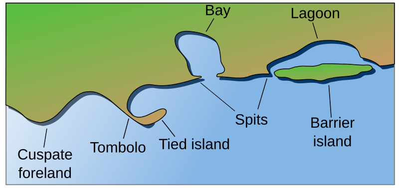
Formation of a spit
A spit is a sand and shingle ridge that extends from a headland out into the sea.
It is formed as prevailing winds result in wave refraction, causing materials to approach the coast at an oblique angle, while they are refracted at 90°. This causes materials to move in a zig-zag fashion, so sediments are transported along the coast due to longshore drift. Deposition occurs at a bend in the coastline, where materials follow the direction of longshore drift rather than the course of the coast. This leads to the formation of a spit at a headland.
Development of beaches
Powerful swash moves material up the land, weaker backwash does not have sufficient energy to remove it. Therefore beach material builds up over time, and the profile of the beach becomes more gradual. The gentle slope reduces the speed of the waves and causes further sedimentation. Material is also deposited in sheltered bays.
Development of sand dunes
Sand dunes form as onshore winds pick up dry sand and blow it up the blow it up the beach. Sand particles deposit behind obstructions such as a piece of wood or plant where they gradually accumulate to form an embryo dune. An embryo dune may be colonised by Maram grass, then developing into a yellow dune and finally a grey dune.
Salt marshes
Salt marshes are shallow, swampy wetlands colonised by saltwater vegetation. They develop in sheltered areas, eg. behind a hooked spit, and the water is often brackish (mix of freshwater from river or land runoff and sea water)
Coastline management techniques
Coasts can be protected against hazards such as flooding and erosion in a number of ways.
Coastline management techniques can be divided into hard engineering techniques, which are typically high-cost, high technology and relatively invasive into the natural environment, and soft engineering techniques, which may be less effective, low-cost, but tend to be more sustainable and work better alongside nature.
Hard engineering techniques:
- Sea walls: these are large, hard walls that can be built along the coastline to reduce erosion and prevent flooding. Sea walls are a common defensive method to protect coasts, but they can produce a strong backwash in waves which undercuts the sea wall.
- Groynes: groynes are usually wooden structures that extend from the coastline out to sea and trap sediments moving along the coastline. Groynes are an effective coastal management strategy to reduce longshore drift, and thereby limit coastal erosion.
- Breakwaters: breakwaters are offshore concrete walls that can break incoming waves from the sea to reduce the force with which the waves crash upon the coastline. This reduces the erosive force of the waves. Breakwaters are very effective at reducing erosion, however, they can also be easily damaged during a storm.
Soft engineering techniques:
- Beach nourishment: Sand and shingle are added to a beach to make it wider. This increases the resistance waves face when travelling across the beach towards cliffs or other hard structures, and therefore reduces erosion of cliffs and similar hard structures.
- Dune grass planting: This is a land management technique in coastal areas where dunes are common. By planting dune grass, dunes are stabilised and become more resistant against storms. Dune grass planting can create a buffer at the seaward front of existing dunes which can be eroded during storms surges.
- Marshland creation: Marshland can be used to break up the waves and reduce the erosive power of the sea. Encouraging the growth of marshland vegetation also limits the area which waves can reach and can thereby help prevent flooding.
Coral reefs
Coral reefs are living ridges of biochemically deposited magnesium and calcium carbonate structure in the sea formed by the growth and deposit of coral. They represent a community of organisms including plants, fish and many other species. Only 0.1% of the ocean floor is covered by coral reefs.
There are three main types of coral reef: fringing reef, barrier reef, atoll.
- Fringing reefs are separated from land (typically an island) by a narrow, shallow lagoon. eg. coral reefs on the coast of Fiji.
- Barrier reefs are at least 500 metres from the coast and seperated from land (typically an island) by wide, deep lagoons. eg. the Great Barrier Reef of Australia
- Atolls are narrow circular reefs that surround a large lagoon. Below the coral reef and lagoon is the former island that has been submerged. eg. Suvadiva atoll in the Maldives
Typically, a fringing reef will evolve into a barrier reef which will develop into an atoll.
Conditions required for development of coral reefs:
- clean,unpolluted water
- clear water, that is less than 60m deep so sunlight can penetrate through the water and allow marine plants to photosynthesise
- warm water temperatures (>20°C)
- water with high salinity (high salinity = high salt content)
Benefits of coral reefs:
- Provide habitat for many species
- Provide food (fish & shellfish) for people living along coastline
- Protect shoreline from large waves by absorbing wave energy
- Source of medicine – some cancer drugs and painkillers use substances from coral
- Provide a safe place for fish to spawn
Resources
A nice video that sums it all up.

October 8, 2022 at 9:20 am
Hello. do you have any notes on the risks of living near the coast?
LikeLiked by 1 person
July 6, 2022 at 8:59 pm
Superb note must be upgraded and add more generally
LikeLike
April 18, 2022 at 7:40 pm
This is really amazing to learn such the important things in living…..
LikeLike
February 10, 2022 at 6:11 am
Hi, due to covid I could not carry out any geographical investigation and the students very weak in paper 4. I need some resources / videos to show them the scenario. Eg : Investigating river velocity, measuring the sand dunes and etc… could you please help with this?
LikeLike
March 20, 2022 at 9:18 am
Hi Pushpakalawaty,
Unfortunately, I won’t be able to help with any videos as I don’t have the time and tools to show these processes in action. The only info I have for paper 4 is on this page, but I remember finding that more than enough for my IGCSE’s back in 2016: https://igcsegeography.wordpress.com/revision-materials/paper-4-alternative-to-coursework/.
I hope this helps, but if not I would recommend looking up Richard Allaway, who may have some more practical content as well.
Best,
Carina
LikeLike
November 19, 2021 at 4:24 pm
My IGCSE Mocks are coming up. would u reckon going through ur notes will be enough? since my textbook doesn’t have a lot of info. If ur notes are not enough, what else do i use?
LikeLike
November 21, 2021 at 11:28 am
Hi lavia,
I think going through my notes will be enough to do well in your IGCSE mocks. But as I created these notes back in 2016, I also recommend going through the IGCSE syllabus and checking which topics you might need more info on. For these topics, two good places to look are Richard Allaway’s geography site: https://www.geographyalltheway.com/igcse_geography.htm and the website created by my former geography teacher: https://www.buddinggeographers.com/
Hope this helps, and good look with your mocks,
Carina
LikeLike
December 1, 2021 at 10:23 am
this is really helpful, Carina! Thank you for your notes 🙂
LikeLike
December 23, 2021 at 5:45 pm
Hi,
I think the first link has expired?
LikeLike
January 22, 2022 at 11:42 am
Thanks for noticing 🙂 I’ve updated the link.
LikeLike
January 25, 2022 at 1:17 pm
um idk if this website has case studies or not but you have to do those as well. study them and practice them. they really take up around 40-30% of the marks
LikeLike
March 20, 2022 at 9:10 am
Hi krish, I share a lot of case studies here: https://igcsegeography.wordpress.com/revision-materials/case-studies/. Hope this helps,
Carina
LikeLike
November 9, 2021 at 6:28 pm
helpful info!
LikeLike
April 30, 2021 at 11:35 am
hi, this has been really helpful for me. Do you have any notes or information about mangrove swamps? Thank you !!
LikeLike
June 8, 2021 at 7:37 pm
Hi zafirah,
A mangrove swamp is an area where a range of trees and shrubs grow in saline or brackish water. Mangrove swamps are usually located near coastal areas. Mangrove swamps can be found along the coasts of Kenya, Tanzania, Madagascar, Costa Rica, New Zealand and several other countries.
The benefit of mangrove swamps is that they provide nutrient rich food and nesting areas for a range of animal species. They also stop coastal erosion and protect the shoreline from hurricanss and tsunamis. Another benefit of swamps is that they trap sediment and debris ahich improves the water quality in tidal rivers. Mangrove swamps are also really important for fisheries and they are a rich source of timber ehich can be harvested on a sustainablr basis.
Hope this helps 🙂
LikeLike
November 8, 2020 at 5:21 pm
its really great! thanks a lot! but can you like put some case studies on coasts like explain how a cost is being protected from erosion or how coastal erosion has affected locals. And can you please put notes on protecting coasts from erosion and all. thanks a lot once again!
LikeLike
November 15, 2020 at 12:13 pm
Hi yahya,
On the case study page, you can find a case study on coastal hazards, coastline management in the Wadden Sea. Additionally, I have added some notes on this page about protecting coasts from erosion. Hope this helps 🙂
Best regards,
Carina
LikeLike
May 31, 2020 at 8:42 am
great simplicity in the explanatioms
LikeLike
May 31, 2020 at 12:18 pm
Thanks a lot!
LikeLike
November 14, 2018 at 5:47 pm
Hello. Your notes are really useful. Do you have some notes on coasts?
Thanks.
LikeLike
November 16, 2018 at 11:02 pm
This is basically my section on coasts/marine processes. Is there anything in particular that you are missing?
LikeLiked by 1 person
November 17, 2018 at 1:53 pm
It would have been great if you added the notes about the factors on why people are attracted to coasts and why are they important. It’s fine though, thanks a lot.
LikeLike
November 22, 2018 at 1:16 pm
Why people are attracted to coasts:
1) for leisure activities including watersports such as waterskiing, jetskiing, boating etc.
2) natural beauty of coasts such as beaches, dunes and cliffs such as white cliffs of Dover
3) coastal climate (sea breeze, smell of the sea)
Why coasts are important:
1) sea fishing
2) ports near coasts facilitate sea trade
3) unique flora and fauna – rich in biodiversity, shallow water provides breading grounds for some animals
This is what I could think of at the top of my head. I hope it helps 🙂
LikeLike
November 24, 2018 at 6:15 pm
Thanks a lot.
LikeLike
September 15, 2020 at 12:14 pm
Wow!! clear explanations
LikeLike
November 8, 2018 at 6:00 pm
i saw ur link for paper 4 alt coursework…besides all that info what else should i study?
LikeLike
November 8, 2018 at 10:41 pm
Dear Daniel,
While I don’t know precisely what will be in the exam, it would make sense to go over all the Paper 1 topics, and the section on Paper 2 as well.
Hope this helps 🙂
Carina
LikeLike
September 17, 2017 at 12:41 pm
nice info 👌👌👌☺
LikeLike
April 30, 2017 at 10:18 am
anything about coral reefs?
LikeLike
April 30, 2017 at 2:04 pm
I’ll add something today or tomorrow.
LikeLike
May 1, 2017 at 8:24 am
Here’s my info.
Factors for the development of coral reefs:
There are three main types of coral reef: fringing reef, barrier reef, atoll.
Typically, a fringing reef will evolve into a barrier reef which will develop into an atoll.
If you have any more questions, just let me know 🙂
LikeLike
April 30, 2017 at 12:41 am
Wow ☺understandable notes
LikeLike